South Big Horn-Red Wall Scenic Backway

Along the South Big Horn-Red Wall Scenic Backway

The eastern end of the South Big Horn-Red Wall Scenic Backway is at the junction of US Highways 20/26 and County Road 125, about 15 miles west of Casper. The Scenic Backway heads north from there, across wide open range and into the lower foothills along the southern side of the Big Horn Mountains.
This is magnificent red rock countryside with huge views, wide dry washes and big, deep canyons. Near the northernmost point on the route you'll be close to the Hole-in-the-Wall area made famous by folks like Butch Cassidy and his Hole-in-the-Wall Gang, among others.
There are some limited-facility campgrounds available at Grave Springs and Buffalo Creek. This area used to be host to many large sheep herds, and sheepherders. You'll find rock cairns placed all through the area to commemorate the many sheepmen and women who have worked in this area over the years.
This countryside is a mix of private, state and Bureau of Land Management properties, so you might want to be sure where you are before you strike off into the distance...
When you emerge at the western end of the South Big Horn-Red Wall Scenic Backway, you'll be at Waltman, another small settlement along US Highways 20/26, about 45 miles west of the eastern entrance to the road.

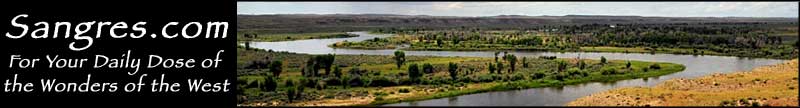
In the Red Wall area, Big Horn Mountains in the distance

Near the Red Wall at the southern end of the Big Horn Mountains

The crossing at Alkali Creek

South Fork of the Powder River

Area map of the South Big Horn-Red Wall Scenic Backway