Great Sand Dunes National Park and Preserve
Frequently Asked Questions

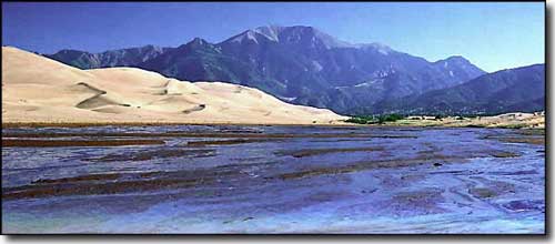
Water flow in Medano Creek, eastern edge of the dunes
Why are the dunes in this particular spot? Since dunefields develop downwind of their sand supply, we need to know what is supplying the sand into this dune system to answer this question. In the past, the sand supplier was thought to be the Rio Grande, but if that were the case we would expect to find dunes along much of its course, not just in one spot. A better explanation is that the sand supply comes from a lake that occasionally fills the northern part of the San Luis Valley. This lake varies in size depending on climatic conditions and can range from being totally dry to being about 16 miles long when completely full. Currently, it is about 1 mile long and is known as San Luis Lake. Streams flow into this lake bringing water and sand. As the lake dries, the sand is exposed to the wind and gets blown toward the northeast. This lake is directly upwind of the dunes and the wind-blown sand starts in the area covered by the lake. The entire valley floor, from the dunefield to the lake area, is covered by sand. Since the lake covers a limited area, the sand blown off it is only found directly downwind of it. That is why there are sand dunes only in this section of the mountain front.
Why are the dunes so tall? Sand dune shape and behavior are the result of the wind patterns that create the dune. In areas where the wind blows mainly from one direction, dunes tend to migrate and are small. In areas like this where the wind blows abundantly in two or more directions, dunes tend to oscillate and get taller over time.
Why do the dunes stop at the base of the mountains? Many people think that the mountains are the barriers that stop the dunes, but the real key is the northeasterly winds and, to a lesser extent, Medano Creek. The northeast winds counter the southwest wind's ability to push the dunes toward the mountains. As we learned in the previous question, dunes in areas with multiple wind directions tend to stop migrating and grow vertically. The position of the large dunes in the dunefield is relatively stable. Along the eastern edges of the dunefield, water flowing down Medano Creek truncates the dunefield and keeps it separated from the mountain front.
Are these dunes unique? Yes, in the sense that every dunefield is unique. However, there are similar dunefields. Look closely at the dunes and notice that there are big sand ridges with smaller sand ridges developed on them. Every dune is connected to the dune next to it, there is no flat space between the dunes.
The Great Sand Dunes are actually one giant dune with lots of smaller dunes superimposed on it. This is a feature called a draa (giant sand dune). There are also draas in California (Imperial Dunes, Eureka Dunes, Kelso Dunes, and Dumont Dunes) and Nevada (Sand Mountain). They have big dunes with similar dune configurations as Great Sand Dunes. They do look a bit like the dunes here. The difference is that they are in very dry areas and the mountains surrounding them are barren. At Great Sand Dunes, the mountains are lush with vegetation and that creates a sense of contrasting environments, as if the dunes shouldn't be here. But we can also find other dunes surrounded by abundant vegetation in Oregon (Oregon Dunes), Idaho (St. Anthony's Dunes), Michigan (Sleeping Bear Dunes) and Maine (the Desert of Maine). There are even dunes on Mars! There is a crater with dunes along the edge that, from space, looks like Great Sand Dunes.
Where are the biggest sand dunes in the world? I did a search for other large dunes and this is what I found. In China's Badain Jaran Desert the dunes are reported to reach 1640 feet. The tallest dunes in the Sahara Desert are around 1500 feet, and in the Namibian Desert they grow to around 1200 feet.
These answers reflect our current scientific thinking about some of the questions asked about this place. When you stop in to visit, ask at the Visitor Center for our free information sheet on geology for answers to other common questions.
Courtesy Andrew Valdez, National Park Service geologist at Great Sand Dunes.
Large Visitor Center Area Map - Full National Park Map
Great Sand Dunes Pages
Great Sand Dunes Index Page - Photo Gallery - Trails to Explore - Maps
Ongoing Research - Great Sand Dunes Partners
